Using the Legend Tool Extension
The Custom Legend wizard is a new ArcView tool for designing state-of-the-art
map legends. You only need to have a layout and one or more views in your project
to use this tool. Unlike traditional ArcView you do not need to have a viewframe in
your layout to add a legend. You only need to click a point at the location where you
want the lower left corner of the legend to be located and your legend will be created
from the view you choose.
To begin using the Legend Tool, open a layout in a project in which you have at least
one view. A new "Custom Legend Tool" button should appear at the right end of the
lower tool bar. Click on this button and then click the approximate point in your layout
where you would like the lower left corner of your legend. The following graphic should
appear.
Click the Next button to advance to Step 1
March 28, 2010
February 16, 2010
Konversi shp ke gdb Menggunakan Global Mapper
Konversi shp ke gdb Menggunakan Global Mapper
1. Buka program Global Mapper. Klik tombol Open Your Own Data Files
atau dari menu command : File > Open Data File
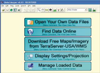
2. Pilih data shp anda yang berbentuk line or polyline
3. Select projection, Zone, Datum and Planar Units yang ingin anda gunakan
lalu tekan OK
1. Buka program Global Mapper. Klik tombol Open Your Own Data Files
atau dari menu command : File > Open Data File

2. Pilih data shp anda yang berbentuk line or polyline
3. Select projection, Zone, Datum and Planar Units yang ingin anda gunakan
lalu tekan OK
February 09, 2010
ArcSDE
ArcSDE
ArcSDE is the GIS gateway to relational databases. It allows you
to manage geographic information in your chosen DBMS and serve
your data openly to the ArcGIS Desktop and other applications.
ArcSDE is a key component in a multiuser ArcGIS system. It
provides an open interface to relational database management systems
and allows ArcGIS to manage geographic information on a variety
of different database platforms including Oracle, Microsoft SQL Server,
IBM® DB2®, and Informix®.
ArcSDE acts as the gateway between the rest of ArcGIS and your
relational database. When you need a very large, multiuser database
that can be edited and used simultaneously by many users, ArcSDE
adds the necessary capabilities to your ArcGIS system by enabling you
to manage your shared, multiuser geodatabase in a DBMS. It does this
by adding a host of fundamental GIS capabilities.
ArcSDE allows you to:
• Manage and maintain your geodatabase in the DBMS that you select.
• Have multiple users edit and maintain the geodatabase. ArcSDE
provides long transaction and version support for your DBMS.
• Serve multiple ArcGIS users anywhere on your network.
Centralizing your DBMS server significantly enhances performance
for large multiuser systems.
• Open your ArcGIS geodatabase to other users who use MapObjects®,
ArcView GIS 3, and computer-aided design (CAD) applications.
• Build Open GIS Consortium (OGC)-compliant applications that work
with features in your geodatabase.
• Build SQL applications that work with the tables and rows in the geodatabase.

January 26, 2010
ArcView, ArcEditor, and ArcInfo Different
ArcView, ArcEditor, and ArcInfo Different
The ArcGIS Desktop can be accessed using three software products,
each providing a higher level of functionality. ArcView provides
comprehensive mapping and analysis tools along with simple editing and
geoprocessing tools. ArcEditor includes the full functionality of ArcView
with the addition of advanced editing capabilities for coverages and
geodatabases. ArcInfo extends the functionality of both to include
advanced geoprocessing. It also includes the legacy applications for
ArcInfo Workstation (Arc, ARCPLOT™, ARCEDIT™, and so on).

January 19, 2010
Transformasi Datum dari UTM ke LATLONG
Transformasi Datum dari UTM ke LATLONG
Transformasi datum di ArcView yang menggunakan extension Projection Utility Wizard
hanya dapat dipakai untuk shapefile tipe polygon dan line.
Untuk tipe point di ArcMap, kita dapat menggunakan
Toolbox Data Management Tools > Projections and Transformation.
1. Buka ArcMap. Klik ikon Show/Hide Arc Toolbox >
Data Management Tool > Projections and Transformations

2. Lalu double klik Define Projection. Masukkan data yang tipenya point,
seperti koordinat desa, kota atau lainnya. Tentukan sistem koordinatnya. OK

3. Pada layer akan muncul data layernya dan menggunakan koordinat
UTM (lihat tanda panah merah)
Transformasi datum di ArcView yang menggunakan extension Projection Utility Wizard
hanya dapat dipakai untuk shapefile tipe polygon dan line.
Untuk tipe point di ArcMap, kita dapat menggunakan
Toolbox Data Management Tools > Projections and Transformation.
1. Buka ArcMap. Klik ikon Show/Hide Arc Toolbox >
Data Management Tool > Projections and Transformations
2. Lalu double klik Define Projection. Masukkan data yang tipenya point,
seperti koordinat desa, kota atau lainnya. Tentukan sistem koordinatnya. OK

3. Pada layer akan muncul data layernya dan menggunakan koordinat
UTM (lihat tanda panah merah)
January 12, 2010
GIS data conversion – overview
GIS data conversion – overview
> In GIS Data conversion has two commonly used interpretations:
- when used in the narrow sense, it refers to the process of
converting existing information to a digital format for use
in a given GIS software package
> In its broader interpretation, it refers to the often
complex process of building databases for GISs.
- Data conversion is usually a costly and a major expenditure
item in setting up a GIS. This situation is brought about by
an interaction of several factors including the large quantity
of data, data that is frequently of indifferent condition/quality
and the complexity of the conversion task. The data conversion
process involves: a plan (incl. manuscript collation, preparation,
information filtering), conversion using appropriate method,
edits/ transformations, format conversions (if necessary) and
data structuring (making the graphic data more ‘intelligent’
by building topology)
- The general (and accelerating) trend has been towards collection
of data in digital format so the main conversion problem is related
to existing data – especially true in developing countries where the
availability of data in digital form is still very limited.
There are many conversion methods; all are befitting from the general
improvement of both hardware and software used in conversion.
Raster scanning is now playing a major role – especially as
the first step in ‘heads-up’ digitising; however, automated data
conversion remains a dream. Automated data conversion is where
a map or similar data source can be scanned and all its geographic
features and properties recognised and extracted by smart software
and converted into a GIS database. It is important to recognise that
the data conversion process can introduce significant errors – only
some of these can be detected automatically by software
(especially so in the case of graphical data)
- The converted graphic data in vector packages is stored simply
as coordinates i.e. as ‘spaghetti’ data. This is relatively ‘dumb’
data i.e. it has no information on spatial relationships
(such as adjacency, intersection and connectivity).
As such any spatial query becomes a tedious process unless
topological structures are created. After topology has been built,
the system is able to respond to queries by using
topological information rather than by a tedious processing
of coordinate (to generate geographic
features every time a query is made)
January 06, 2010
GIS OVERVIEW
GIS OVERVIEW
Definition of GIS
A system of hardware, software, data, people, organizations and institutional
arrangements for collecting, storing, analysing and disseminating information
about areas of the earth. (Dueker & Kjerne 1989:7-8)
“The organised activity by which people:
- Measure aspects of geographic phenomena and processes
- Represent these measurements, usually in the form of a computer database,
to emphasize spatial themes, entities and relationships
- Operate upon these representations to produce more measurements and to
discover new relationships by integrating disparate sources
- Transform these representations to conform to other frameworks of entities
and relationships” (Chrisman 1997:5)
GIS as an Information System
January 03, 2010
Registrasi Peta
Registrasi Peta
Untuk meregistrasi peta jpg agar posisinya sesuai dengan koordinat bumi
maka peta jpg tersebut harus mempunyai minimal 4 titik koordinat.
Salah satu cara registrasi peta jpg yakni menggunakan extension
TerraExplorer Image Tools. Sebelumnya, Terra Explorer harus sudah
terinstall di komputer anda dan otomatis ekstensi *.avx-nya akan ada
di folder C:\ESRI\AV_GIS30\ARCVIEW\EXT32
1. Buka ArcView Gis lalu klik menu File > Extensions…
Beri tanda centang TerraExplorer Image Tools,
Image Analysis dan JPEG (JFIF) Image Support, OK.


2. Muncul icon TerraExplorer Image Tools. Lalu klik icon tersebut.
Maka muncul window Image …..

3. Klik icon add control point, maka akan muncul window image Registration
January 01, 2010
Hitung luasan dan keliling polygon
Hitung luasan dan keliling polygon
Salah satu cara untuk menghitung luasan dan keliling polygon wilayah
digunakan extensions Xtools.avx
Berikut langkah-langkahnya :
1. Buka file polygon yang ingin anda hitung (disini contohnya sultra). Lalu klik menu
File > Extensions…
Beri tanda cek pada extensions XTools Extension-Meters/Hectares, OK

2. Maka menu command XTools akan muncul. Lalu klik XTools > Update area,
perimeter, hectares and length.

3. Muncul window calculate feature size. Pada kolom, pilih theme sultra, OK
Crop Raster Image
Crop Raster Image
1. Open the ArcView program. Add Image Analysis extensions in
File > Extensions > Image Analysis. Click Add theme icon then select
raster image. Click Image Analysis > Properties …

2. Choice In the Analysis Extent drop down list and Analysis Mask drop down
list shp polygon.

3. Click image raster theme. Then Click Image Analysis > Subset..


