Using the Legend Tool Extension
The Custom Legend wizard is a new ArcView tool for designing state-of-the-art
map legends. You only need to have a layout and one or more views in your project
to use this tool. Unlike traditional ArcView you do not need to have a viewframe in
your layout to add a legend. You only need to click a point at the location where you
want the lower left corner of the legend to be located and your legend will be created
from the view you choose.
To begin using the Legend Tool, open a layout in a project in which you have at least
one view. A new "Custom Legend Tool" button should appear at the right end of the
lower tool bar. Click on this button and then click the approximate point in your layout
where you would like the lower left corner of your legend. The following graphic should
appear.
Click the Next button to advance to Step 1
March 28, 2010

February 16, 2010
Konversi shp ke gdb Menggunakan Global Mapper
Konversi shp ke gdb Menggunakan Global Mapper
1. Buka program Global Mapper. Klik tombol Open Your Own Data Files
atau dari menu command : File > Open Data File
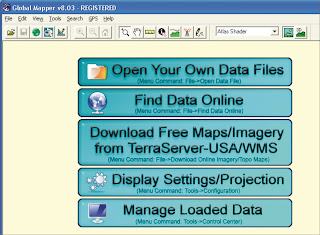
2. Pilih data shp anda yang berbentuk line or polyline
3. Select projection, Zone, Datum and Planar Units yang ingin anda gunakan
lalu tekan OK
1. Buka program Global Mapper. Klik tombol Open Your Own Data Files
atau dari menu command : File > Open Data File

2. Pilih data shp anda yang berbentuk line or polyline
3. Select projection, Zone, Datum and Planar Units yang ingin anda gunakan
lalu tekan OK
February 09, 2010
ArcSDE
ArcSDE
ArcSDE is the GIS gateway to relational databases. It allows you
to manage geographic information in your chosen DBMS and serve
your data openly to the ArcGIS Desktop and other applications.
ArcSDE is a key component in a multiuser ArcGIS system. It
provides an open interface to relational database management systems
and allows ArcGIS to manage geographic information on a variety
of different database platforms including Oracle, Microsoft SQL Server,
IBM® DB2®, and Informix®.
ArcSDE acts as the gateway between the rest of ArcGIS and your
relational database. When you need a very large, multiuser database
that can be edited and used simultaneously by many users, ArcSDE
adds the necessary capabilities to your ArcGIS system by enabling you
to manage your shared, multiuser geodatabase in a DBMS. It does this
by adding a host of fundamental GIS capabilities.
ArcSDE allows you to:
• Manage and maintain your geodatabase in the DBMS that you select.
• Have multiple users edit and maintain the geodatabase. ArcSDE
provides long transaction and version support for your DBMS.
• Serve multiple ArcGIS users anywhere on your network.
Centralizing your DBMS server significantly enhances performance
for large multiuser systems.
• Open your ArcGIS geodatabase to other users who use MapObjects®,
ArcView GIS 3, and computer-aided design (CAD) applications.
• Build Open GIS Consortium (OGC)-compliant applications that work
with features in your geodatabase.
• Build SQL applications that work with the tables and rows in the geodatabase.

ArcSDE is the GIS gateway to relational databases. It allows you
to manage geographic information in your chosen DBMS and serve
your data openly to the ArcGIS Desktop and other applications.
ArcSDE is a key component in a multiuser ArcGIS system. It
provides an open interface to relational database management systems
and allows ArcGIS to manage geographic information on a variety
of different database platforms including Oracle, Microsoft SQL Server,
IBM® DB2®, and Informix®.
ArcSDE acts as the gateway between the rest of ArcGIS and your
relational database. When you need a very large, multiuser database
that can be edited and used simultaneously by many users, ArcSDE
adds the necessary capabilities to your ArcGIS system by enabling you
to manage your shared, multiuser geodatabase in a DBMS. It does this
by adding a host of fundamental GIS capabilities.
ArcSDE allows you to:
• Manage and maintain your geodatabase in the DBMS that you select.
• Have multiple users edit and maintain the geodatabase. ArcSDE
provides long transaction and version support for your DBMS.
• Serve multiple ArcGIS users anywhere on your network.
Centralizing your DBMS server significantly enhances performance
for large multiuser systems.
• Open your ArcGIS geodatabase to other users who use MapObjects®,
ArcView GIS 3, and computer-aided design (CAD) applications.
• Build Open GIS Consortium (OGC)-compliant applications that work
with features in your geodatabase.
• Build SQL applications that work with the tables and rows in the geodatabase.


