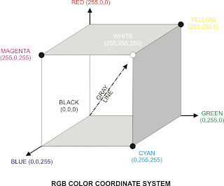
Digital remote sensor data are usually displayed using a Red-Green-Blue (RGB)
color coordinate system, which is based on additive color theory and the three
primary colors of red, green and blue. Additive color theory is based on what
happens when light is mixed, rather than when pigments are mixed using
subtractive color theory.
For example, in additive color theory a pixel having RGB
values of 255,255,255 produces a bright pixel.
Conversely, we would get a dark pigment if we mixed equally high proportions of
blue, green and red paint (subtractive color theory).
Using three 8-bit image and additive color theory, we can conceivably
display 224=16,777,216 color combinations.
For example, RGB brightness value of 255,255,0 would yield a bright yellow pixel
and RGB brightness values of 255,0,0 would produce a bright red pixel. RGB values
of 0,0,0 yield a black pixel.
Grays are produced along the gray line in the RGB color coordinate system when
equal proportions of blue, green and red are encountered
(e.g., an RGB of 127,127,127 produces a medium-gray pixel on the screen or
hard-copy device).
Jensen John R. 2005. Introductory Digital Image processing-A Remote Sensing Perspective. 3rd edition. chapter 5. Pearson Prentice Hall.
skip to main |
skip to sidebar
My Great Web
Tempat Berbagi Informasi dan Tutorial Seputar Penginderaan Jauh dan GIS
Choose Your Language
by : BTF
Popular Posts
-
Content terdiri dari : 1. Remote Sensing in the Optical and Microwave Regions 2. Pattern Recognition Principles 3. Artificial Neural N...
Followers
Pengunjung
Total Pageviews
Blog Archive
Ma'had Al Ilmu Limboto
Site Content
ATTHETRUTH. Powered by Blogger.


0 comments:
Post a Comment